Friday

DOQQ


DOQQ- Digital Orthophoto Quarter Quadrangle


http://www.isgs.uiuc.edu/nsdihome/webdocs/doqs/images/charleston_q30.jpg

DEM


DEM- digital elevation map


www.satimagingcorp.com/gallery/dem-3d-2.html

Isohyets


Isohyets


http://www.bom.gov.au/lam/climate/levelthree/c20thc/events/maitlandl.gif

Isotachs


Isotachs


http://weather.cod.edu/help/700tach.gif

Isobars


Isobars


http://wxmaps.org/pix/avnmr5.00hr.png

Topographic Map


Topographic Map


http://www.globalwarmingart.com/wiki/Image:Florida_Sea_Level_Risks_png

This topographic map was contoured using color and shading for relief.

PLSS Map


store.armstrongmapping.com/index.cfm?fuseacti...

Remote Sensing


Remote Sensing-


http://trmm.gsfc.nasa.gov/affinity/download_kmz.html ----}
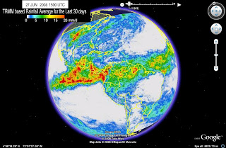
http://trmm.gsfc.nasa.gov/trmm_rain/Events/30_day_average.kml

This is a remote sensing KML image reflecting the average precipitation over a period of thirty days in 2007 (around June) with the moderate amounts of rainfall shown by the green regions and the most rain depicted in the dark red areas. This type of information is produced by using infrared emulsion receptive to wavelengths that are indiscernible to human vision, as well as microwaves and visible waves.